Detection, chemistry, application, verification and reporting all sit inside one CASA-certified operation. No subcontract chain, no hand-offs between a survey provider, a spray contractor and a consultant — one accountable crew and one evidence standard from first flight to final report.
Closed-loop weed control
Most providers do one end of this. We do all three: map the weeds wall-to-wall, treat them with rate-controlled application, and hand back the record.
Detect
Wall-to-wall aerial weed mapping over a survey-grade orthomosaic.
Treat
Variable-rate application — DJI Agras T100 aerial and GPS-guided ground units — held on-target.
Record
GPS spray records, product rates and treatment maps for every job.
Mapping drives the spray plan. Application is variable-rate, held on-target and recorded pass-by-pass — and every job is returned with GPS spray records, product and rate data, and treatment maps, so works can be verified, regrowth monitored and compliance demonstrated.

One crew, every method
Method is matched to species, density and terrain — and methods are combined on the same job where the country calls for it.
Variable-rate spray and spreading.
Boom and spot application.
Sensitive and riparian country.
Woody weeds.
Applied to label, recorded on every job
Every applicator holds ChemCert / AHCCHM307. Products are selected to species and situation and applied to label, with water and product rates matched to infestation density block by block. Mixing, handling and hygiene are recorded on every job, with compliant dangerous-goods storage in place.
The same aerial application capability serves broadacre, horticulture and pasture programs — variable-rate, ChemCert-accredited and recorded pass by pass.
Run as a program, not a visit
Baseline detection sets the treatment plan. Every application is verified against it from GPS as-applied records, regrowth is monitored round-on-round against the baseline, and follow-up treatment is scheduled until control is achieved.
Treatment planning and works programs, built over the survey baseline and aligned to OAMP / EPBC obligations where offsets apply.
RTK / PPK positioning, variable-rate flow control, GPS guidance on ground rigs, spray-diary capture on field tablets — every pass geolocated as it happens.
GPS spray records, as-applied coverage maps, product and rate data and compliance summaries — delivered in your GIS formats.
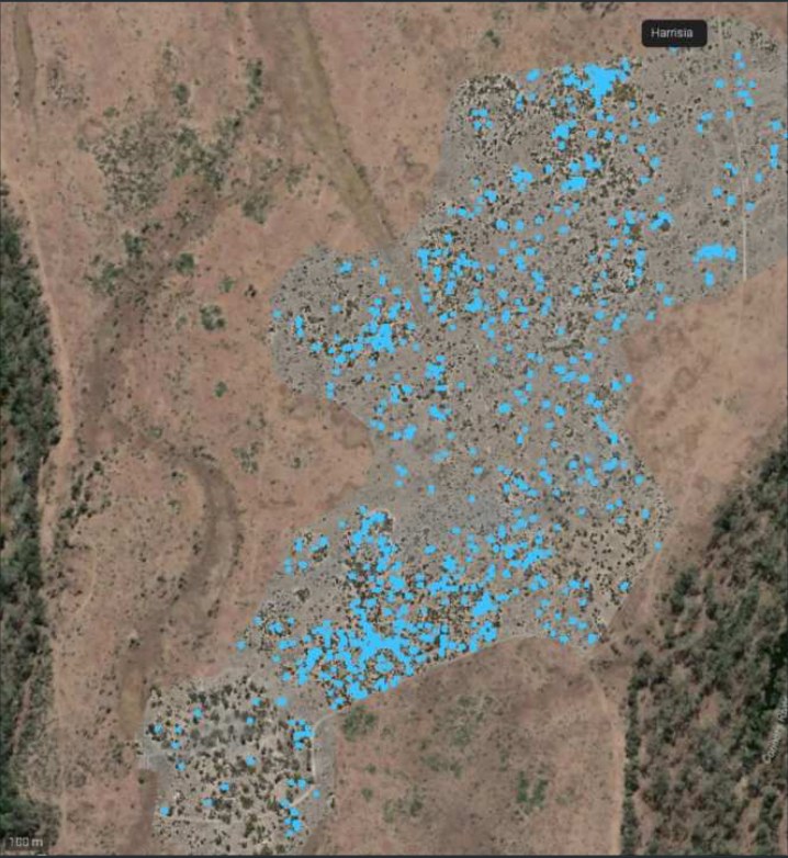
Harrisia cactus control across a 560 ha environmental offset
A 560 ha riparian offset in the Bowen Basin, evidenced to compliance standard over four campaigns. Every figure is drawn directly from the survey and as-applied application records; site and client details withheld.
Drone weed spraying questions
How much does drone weed spraying cost in Queensland?
Pricing depends on area, weed density, access and chemistry, and is quoted per job rather than a flat per-hectare rate. A typical mine-site or pastoral program is scoped from a wall-to-wall weed map first, so you only pay to treat what is actually there. Call 1300 544 968 or request a quote for a fixed price within 48 hours.
Which weeds can you spray by drone?
Harrisia cactus, parthenium, giant rat’s tail grass, leucaena, rubber vine, lantana, prickly acacia, buffel and most declared Queensland weeds. Chemistry is selected to species and situation and applied to label by ChemCert (AHCCHM307) accredited applicators.
Where do you operate?
Based in Mackay, we run drone weed spraying across the Bowen Basin (Moranbah, Dysart, Middlemount, Clermont, Blackwater), the Central Highlands around Emerald, the Isaac and Whitsunday regions, and Australia-wide by arrangement.
Are you CASA certified and mine-site ready?
Yes. Dronehab holds a CASA ReOC, crews are mine-inducted, and every job is delivered with a site-specific SWMS, spray records, product and rate data and GPS treatment maps for your compliance file.
What drone do you use for spraying?
The DJI Agras T100, flown with RTK positioning and variable-rate flow control, backed by GPS-guided UTV ground units and handheld crews for steep or sensitive country.
Can you do the mapping as well as the spraying?
Yes. We map the infestation first with a survey-grade orthomosaic, treat from that map, then re-fly to verify kill and schedule follow-up. One crew, one dataset, one accountable report.